Road Trip Part 3: Land of Enchantment

For part one of this series, see Paradise on The Platte.

For part two, see Captured By Kansas.

photo 3(14)

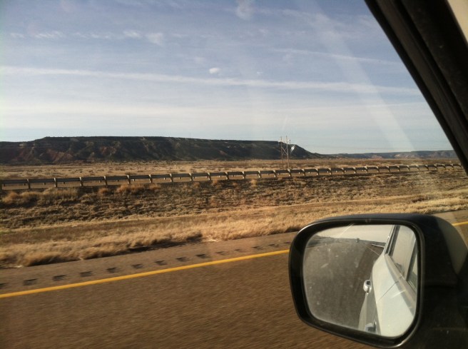
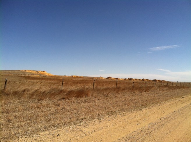
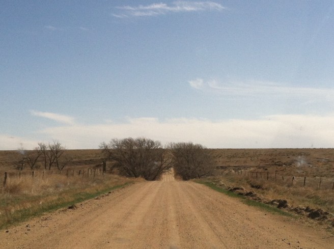
Past Elkhart, the road roughened crossing into Oklahoma; glass insulators gleamed on power poles stretching to the distance. The route through the Panhandle at this point is 71 miles of loneliness, punctuated by Boise City, threading just south of Colorado’s border and north of Texas by a hair.

Rabbit Ear Mountain, that sentinel of U.S. 56, loomed as I passed into the Land of Enchantment, and I gained an hour from Mountain Time. Twelve more miles got me to Clayton, where I pulled off to a parking space along the main drag and, realizing I had the tools to avoid the hot beef disaster from earlier in the day, asked my phone where to eat.

I also really, really wanted a cold beer. My butt was killing me from two days of driving, and there were motels visible from the parking lot. I had made it to New Mexico. I could eat and crash. But there was no beer available at The Rabbit Ear Cafe–just the typical line-up of sodas, plus real brewed iced tea–which ended up being the perfect accompaniment to my awesome tamale plate with green chile sauce and homemade beans and rice. I walked out the door somewhat revived and completely satisfied, and with the rest of my tea in a to-go cup, sat down on a bench with my road atlas to decide what to do next.

U.S. 56 ends at Springer and Interstate 25, which heads south toward Las Vegas (no, not that Las Vegas) and then loops up toward Santa Fe, then down again toward Albuquerque and eventually, Los Cruces. My intention was to avoid long stretches of  interstate and heavily populated areas as much as possible (as well as going north when I meant to go south) while making my way across the state and into southeastern Arizona, so I wanted an alternate route. Fortunately, there is this little two-lane (402) running from Clayton to Nara Visa, which sits at the junction of another diagonal highway, U.S. 54. With a fresh infusion of caffeine coursing through my veins and an hour or two of daylight left, why not?

New Mexico is not only gorgeous, has more consistently delicious food than most other states, and is fully deserving of its “Land of Enchantment” moniker, it is really, really big. Despite getting one measly page in my road atlas (while horizontal Kansas, Nebraska, and the Dakotas all get two), New Mexico is the fifth largest state. And, when you consider that its ranking puts it behind only the truly enormous states of Alaska, Texas, California, and Montana–well, it’s hard for a New Englander–even one turned prairie gal for over two decades–to fully comprehend. Unless, of course, she drives across it. Twice.

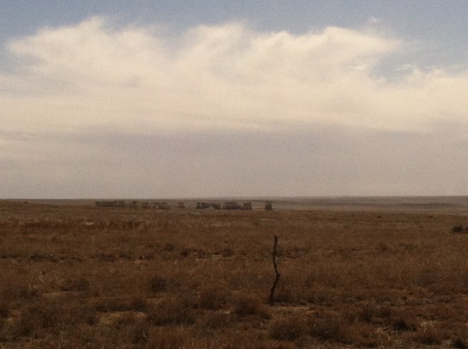
New Mexico 402 is a narrow, lonely two-lane through the Kiowa National Grassland hills blazing in the sunset. There are two towns between Clayton and Nara Visa that (as I discovered is true for many points on the New Mexico map) are virtually abandoned. Or probably there wasn’t much there to begin with. Either way, the service they provide is more about seeing that you are making progress toward your destination than giving you a place to pee or buy a cold drink. You quickly learn to use the bathroom and gas up whenever you get a chance rather than waiting for the next town indicated on the map.

From Nara Visa, it is another 24 miles to Logan which, despite being the same font size on my map as many other towns with no services, has plenty of them due to the presence of Ute State Park just on the edge of town. I pulled into a cute little motel called the Yucca and, after petting the office kitty, got a room for less than forty bucks. It was a little shabby in that old-family-run-motel-near-the-state-park kind of way, but it was perfectly clean, and the decor was old-school kitschy cabin goodness.

photo 1(25)
Antler lamps & handmade doilies
photo 2(22)
Vintage chenille
photo 3(15)
Jigsaw under glass

I ended up staying in the Yucca twice–once on the way out, and once on the way back. My only real disappointment there was failing to eat at the cafe next door, whose chile-laden menu is displayed over four delicious photocopied pages in the hotel rooms’ information book. I missed it on my way into town when all I wanted was bed (and one of the beers in my cooler), and when I left the second time, it was 5:45am and I assumed it wouldn’t be open (it was, but with a major storm rolling in to the north, I was thinking more about miles than a meal).

The gas-and-restroom lesson is one most travelers of rural regions are familiar with, but the other hard lesson of this trip (and one that never quite set in) was taking off in the morning without eating first–especially when there was a promising-looking cafe in the vicinity. I’m not usually an early eater, but by late morning I can get desperate enough to make a bad choice. That happened in Hoxie, Kansas, and it might’ve happened again in eastern New Mexico had there actually been any place to eat on my route (though, as I said before, New Mexico doesn’t seem to have much bad food).

I passed through Tucumcari (TWO-come-carry) and it was still too early to eat; I followed a sliver of I-40 to Santa Rosa and then south again on 54 and west on 60. By the time I got to Willard, I was desperate enough for a bathroom that I begged the postmistress to let me use hers–only then seeing “No Public Restroom” signs on the door she blessedly unlocked for me. But there wasn’t anything else public in Willard–all the old business were boarded up with “For Sale” signs bleached from the sun, and the grassland plains don’t offer much to hide behind along the roadside.

photo 1(25)
No place to pee here…

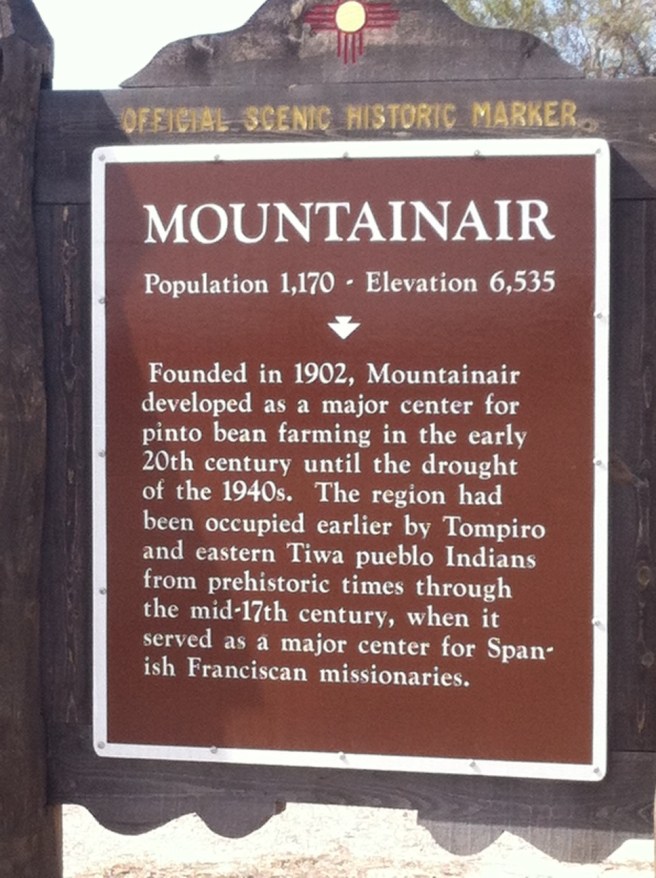
In Mountainair, I stopped in front of the historical marker and tried to use my phone again to seek out food, but I couldn’t even get a signal. Then, looking off to the side, I saw a sign advertising an old, historic inn nearby with great, fresh food and a welcoming atmosphere. It turned out to be closed as well, so I headed back to the main drag behind an old lime-green painted Chevy pickup with Bernie Sanders “Honk for a Political Revolution” and “Wolves Against Sarah Palin” stickers. Yes, I was truly in New Mexico.

Parked in front of the post office, I practically assaulted a young woman walking down the street (she had ear buds in) in order to find a place to eat. Once she realized I was yelling at her, she smiled broadly, pulled out the buds, and pointed me to Alpine Alley–a funky little coffee house and sandwich place where the regulars are crusty with each other, but kind and generous with visitors. In keeping with my vow to eat green chile at every meal in New Mexico, I had the “Sophia Loren” wrap and grabbed a scone for the road.

photo 2(22)

From Mountainair, I headed on, down into the Rio Grande Valley, and then up through the mountainous western part of the state. For that tale, my friends (which includes the Continental Divide and famous PieTown–see how I managed to keep my green chile pledge!), you’ll need to read the next installment of the road trip series.


The Gardenless Season?

I haven’t started a single thing under lights this year, nor have I planted a seed (or a potato tuber, or anything else) in the ground.

I haven’t ordered any new seed (though I have a plentiful supply on hand). Seed inventory took place just after the new year, and although I made notes about what to order, I never followed through.

In a typical year, I’d start leeks and onions mid-February–March 1st at the latest. Peppers and eggplant (and perennial herbs and flowers) would be next, followed by tomatoes a few weeks later, then cabbages, broccoli, lettuce, etc. By this time in a normal season, I’d be running low on seed-starting mix and castigating my worms at how slowly they were turning kitchen scraps into fertilizer for the next batch. I’d be poking around the pea patch daily, looking for signs of sprouting, and the spinach and arugula would be up under the row covers.

The fact that I haven’t sown a single radish might seem even stranger since I’m back at the farmstead where I ran a 20-family CSA and market garden business. My vermicompost bin is here, and my light shelf (though not in the house, nor assembled), and there’s a bale of peat and bags of PBH (parboiled rice hulls–for loft and drainage) in the storage unit. I’ve got flats and cell packs as well as soil block makers. My tools are here, too. So what the hell am I waiting for?

early spring garden
Spring 2008 Market Gardens
1588b
Another View Through the Mulberries
coat hanger
Fall Cleanup West Garden 2008

This morning on Facebook, I saw a “memory” from five years ago–a post from this day on a former blog wherein I reported building four raised beds for the backyard of a house I was renting in a little town in Minnesota. There was landscape rock to remove on a flower bed in front, and also another field garden of about 600 square feet to cultivate in back. In the post, I was relating how many gardens I’d built and then left behind (spoiler: I left that one, too, when the house burned while I was visiting family back East). I even said something about maybe getting too old to keep doing that.

And that, my friends? That was three built-then-left gardens ago.

And these were no mere 100-square-foot plots. The next one was composed of four raised beds (the same ones–friends helped me lift the frames and move them across town to my new place) plus two newly-developed 20×80′ field gardens. That’s nearly 3400 square feet of growing space. Then the farm, with 18 raised beds, a 40×40′ lower field garden, plus a 30×30′ upper field garden newly cultivated last year (and in which my fall-planted garlic crop presently resides).

DSC05010
One of the two 20×80′ plots, Clinton, MN 2012
photo 2(3)
June 2014 Raised Bed & Lower Field Garden at the Farm

I guess if I was getting too old for this five years ago, then I wouldn’t have gone on to do even more in subsequent years. I could say that this year is different because I was moving during most of February and much of March–except that I moved to the aforementioned rental house in mid-March of 2011 and it burned in early August, and I still had a full garden there. I simultaneously managed both the Clinton house gardens and developed the farm gardens, helped with house renovations, moved (and helped my husband move) in the spring of 2013. So, I know it’s entirely possible to start seeds and plan a garden even in the process of moving.

But maybe this year, instead of just getting older, I am getting (OK–trying to get) wiser about garden development. As in, not doing so much, so quickly, and then having so much ground to manage and food to process. So much stress when there’s a window of good weather to plant, but the equipment isn’t working or there’s a work project taking precedence or some damn other thing is getting in the way of what absolutely needs to be done in the gardens right this bloody second ARRRRRRGH!

And then, there’s this:

DSC06463DSC06462

This is what the old market gardens look like now.

I hesitated a little to even show these images because I don’t want the people who grew here last year to feel bad about it (even though they’ve already told me they feel bad about it–don’t feel bad about it!). Life happens. In their case, a baby happened. And when a baby happens…well, this can happen, too.

And it’s totally, completely OK. Because it also happened to make me less inclined to make myself crazy about an acre or so of ground that might be better off planted into cover crop and maybe some fruit trees next year. And yeah, I will probably till some up and throw in some potatoes. And I may have pulled a couple of flats and some other seed starting supplies out of the storage unit last night. And a few boxes of seed out of my stash. And I might do a little, but I won’t do it all. And that is also totally, completely OK.

Because what I’ve decided about this place, and also about myself, is that it’s time to take a lot broader view than a perfectly cultivated garden on a little patch of ground. There’s a lot more that I could do–both on this 90 acres and in the world and my life, too. It’s just not worth making myself crazy about regaining “control” over a little patch of ground when I could be developing a plan that, over time, would improve the whole in ways that slowly, methodically, eventually, work to the benefit of everything that lives here (OK–except the brome and cedars–death to the brome and cedars).

Although it will be a season of less garden, it will not be altogether gardenless. And it will be full of beauty and appreciation nonetheless.

Now, then. Time to start some seeds.

Road Trip Part Two: Captured By Kansas

For part one of this series, see Paradise on the Platte.

photo 3(14)

The epiphany of the cranes and the Great Interstate Archway provided energy enough to put on a few more miles that first night. From Kearney, I headed south and west through Axtell and Funk to Holdredge, where I paused to gas up.

After being nailed by a heavy downpour on I-80, I was wary of the fact that thunderstorms were developing in several directions–it’s one thing to be engulfed by one in the daylight, but quite another at night, on hilly, dark two-lanes full of truck traffic out on the High Plains. The young man at the filling station took my snack money (you pay at the pump after dark) and said, “be careful out there,” which, considering the lightning crackling to the north, I took to refer to the weather and not anything sketchy about the town itself.

South from there on 183, over twenty miles of dark road and lightning on three sides to Alma, on the Republican River and near the border. There are several motels there, but I didn’t want to stop until Nebraska was behind me, so on I went over the river and into The Great State of Kansas. From there, I picked up 383, a diagonal state highway marked with the ubiquitous golden sunflower (that, I’m sorry, looks like an amoeba when it’s stretched to encompass three digits),  running along Prairie Dog Creek through the northwest corner of the state.

It was dark, and concentration was flagging. I can see well enough driving in the dark, but my eyes wearied of watching for deer, and oncoming headlights were making it worse. A semi came up behind me; the road was winding; there wasn’t anywhere to pull off. Even after adjusting my mirrors to cut the glare, it was obvious I was just going to have to hole up in the next available place.

Thankfully, I spotted a water tower ahead, and a neat-looking little town just off the highway–well-lit and promising a bed for me. I slowed; the semi passed me, and I was executing the turn before I saw the sign: “Norton Correctional Facility.” Oh, hell. Probably not the bed I was looking for! But, where there’s a prison, there’s a town for its workers to live, and I found that and my rest just a couple more miles down the road.

High wind warnings for the next day drove me out early and without breakfast–just a couple cups of mediocre motel coffee and the belief that I’d find interesting food somewhere down the road. The idea was to stick on 383 southwest, then hook up with 83 down to Oakley, before turning west on 40 and into Colorado, toward the Sand Creek Massacre site.

Or, maybe I’d go further south on 83 and check out some points of interest before picking up 96 west. Either way, the early part of the day would get me to Colorado, and then a right turn would have me entering New Mexico by sundown. It turned out to be a good thing I’d planned some flexibility in my route because it flexed a lot more before the day was done.

photo 1(24)
While this is in Kansas, it is not a U.S. Highway, no matter what you might have heard.

The morning went by along with several small towns, none of which had the requisite number of pickups parked in one place to signify a good Midwestern cafe. I craned my neck hard passing through Jennings–a sign read “Czech Us Out!” and I was thinking I could “Czech out” some kolaches, but no such luck, at least from what was visible passing through. Outside Selden about a mile, the highway was completely blocked off and closed (for no ascertainable reason, so…zombie invasion?). A detour forced me to backtrack east six miles, then south to Hoxie.

By the time I hit Hoxie, the wind was howling out of the north, and I was starving. I drove around town twice looking for a likely cafe, and stopped at one on the main drag where, fighting gusts, I managed to exit my car and order what was bar-none the worst hot beef sandwich of my entire life. Hints were there, of course, in the multiple blaring TV screens and coffee “whitener” nestled next to the fake sugar packets. The artificial potatoes were so cheap, they didn’t even bother adding potato flavor, and don’t get me started about the gravy. Just awful.

But, like a good Midwesterner, I ate it, said it was “fine,” and got back on the road, vowing to snack on gas station crap rather than letting myself get desperate enough to repeat that experience. If I’m going to take time to stop and eat, I’d like it to taste better than dried out chemical-laden “croissandwiches” from a rotating warmer cabinet by the highway.

To get back on my intended route, I needed to head west, and west was getting really, really difficult with sustained winds in the 40mph range. Tumbleweeds attacked by the dozens, and semi trailers noticeably shuddered in the gusts. At Oakley, I gassed up–and gave up–on the Colorado route, letting the Kansas wind capture me and sail me straight south.

And what a blessing that turned out to be. “Everybody likes to hate on Kansas,” a friend from there exclaims. I guess it’s probably like Nebraska in that its attractions are not well-known, and it’s in the way of getting to “cooler” states like Colorado and…um, Colorado. Heading straight down the west side of Kansas not only gave me ten extra miles per gallon, but the definitive knowledge that there are, in fact, some really cool things to see there.

The first one is Monument Rocks National Natural Landmark. You might think that because it’s called a “National Landmark” that it’s nicely accessible with a paved parking lot and clean restroom facilities. Actually, it’s located on private property seven miles off the pavement and over a couple of cattle grates (which means, yes, there are cattle grazing in and around the limestone formations). There are no facilities other than what you might’ve brought with you. And it’s really, really cool.

photo 2(22)DSC06440photo 3(15)DSC06445

Out there in the wind and sun, being blasted by limestone eroding off the formations, it’s worthwhile to remember that you’re standing at the bottom of what was once a vast inland sea. Though, you might not know it unless you have some grounding (heh–get it?) in geology, or you stop at the information kiosk on the main highway–because there are no signs out here except those that tell you not to climb on the rocks.

Back on the highway, I traveled a few more southerly miles before dropping down into Scott State Park, nestled in a canyon and situated around a pretty, spring-fed lake. The park staff were all in the office when I walked in, and provided my $5 day pass along with lots of maps, information, and suggestions of other points of interest along my route. But the purpose of my visit there had less to do with the lake or getting out of the wind (that was really nice) than visiting the northernmost pueblo ruins in the United States.

That’s right–they’re in Kansas.

DSC06447

El Cuartelejo (as it’s now known) was constructed around 1664 by a group of Taos Indians fleeing Spanish rule. It was inhabited by a few other groups before being abandoned in the 1700s and later re-discovered by white homesteaders on the land, excavated, and the foundation reconstructed.

The foundation itself was not as interesting to me as the story–more unknown than known–and standing right there on land settled three-and-a-half centuries ago by people who were a long, long way from home. What was their journey like? How long did it take? Why did they travel so very far north? And, turning slowly around to take in the landscape, what factors are visible to me that helped them decide on just this location to build a “permanent” resting place?

DSC06448

The third stop I made that early afternoon was one I would not have bothered with had it not been for the state park staff. “Battle Canyon” is only a couple of miles down the road from the park office, and it didn’t appear on my maps. It looks to be on private property, but there is an information kiosk and guest register across a cattle grate and at the foot of a short, but winding, washed out, and rocky road to the monument on top.

photo 1(24)

Having had my butt in a car seat for much too much of the day already, I strapped on my hiking boots and did a little climbing down in the canyon, which is reputed to be the site of the last Indian battle in Kansas–between the U.S. Army and a band of Northern Cheyenne that had been removed to a reservation in Oklahoma and got fed up (no pun intended) with the sickness and starvation there, so decided to head back home (against the government’s wishes) to Wyoming, where they could take care of themselves.

photo 2(21)
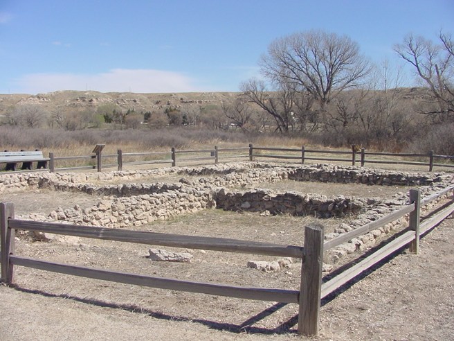
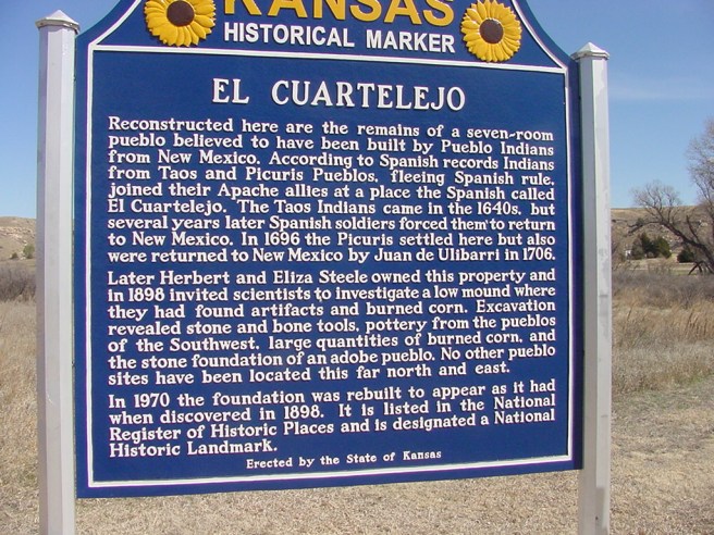
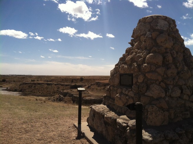
There’s a lot of “wild west” anti-Indian bull-crap still out there, even in today’s supposedly enlightened world, so I was really pleased to read the handout on the “Battle of Punished Woman Fork,” which was written from the perspective that, hey, this band of Northern Cheyenne was being starved and sickened by genocidal U.S. government policies, and they did what they had to do for the good of their people, despite being chased down, attacked, and killed for trying to get home. And at least in the battle that took place here–they won.

Getting back in my car and looking at the time, I realized that as cool as western Kansas was, if I wanted to be in New Mexico by nightfall, I needed to put some serious miles under me. I made it past Garden City (which is as lovely as the name suggests) and into a landscape that starts to look more and more like the southwest–irrigated wheat fields giving way to sagebrush plains and feedlots with their haze of pulverized manure dust. Near Sublette, with the wind dying down, I picked up U.S. 56 and resumed a somewhat westerly route through Cimarron National Grassland, and into the Oklahoma Panhandle.

Next installment: Out of the Panhandle and Into Enchantment.


Road Trip Part 1: Paradise on the Platte

photo 1(23)
Crossing over…

In early February, I got a call from an old friend in Southeast Arizona whom I hadn’t seen in a few years. She’d heard I was moving (and yeah, also about the divorce and leaving my job), and wondered if, being somewhat untethered by other obligations however briefly, I might want to pay her a visit and see some of the work she was doing for a watershed restoration project down in the Chiracahua Desert.

Now, I’m not much of a desert girl, but after six winters in Minnesota (during which I learned I’m a much happier person if I commit to wearing long underwear every day), getting to a warmer clime for a week or two, seeing things growing and flowering (even on otherwise inhospitable plants), and eating lots of green chile seemed like a really fine idea.

Still, it was a full month (filled with packing and moving, stresses and negotiations and endless hours on the road) before the trip blossomed as a genuine possibility in my mind. The date for leaving was set not quite a week in advance, and all the fine details about animal care and car tune-up and eating all the leftovers came quickly after.

The day before I departed south- and west-ward, I drove the seven-hour round trip north to Minnesota to deliver the dog to my ex, pack my garden tools, and give him a tour of what herbs were popping up in the gardens that he could eat. Then, to stretch my muscles a little more (and because I couldn’t stand the look of the thing), I spent another half hour or so cutting back and cleaning up perennials in the triangle prairie garden I planted last summer.

Needless to say, I didn’t plan on leaving first thing the following morning. But the majority of that calculation didn’t have anything to do with the time I’d spent on the road the day before. It had to do with cranes.

I’m not a big subscriber to the whole “Bucket List” mentality–maybe because there are lots of things I have wanted to do before I die that turned out (so far) not to be a big deal whether I did them or not. But, after explaining that to my kid and describing my own list as “stuff I’ve really wanted to see or do if ever I get the chance,” he turned to me and said, “Mom, I think that’s pretty much a Bucket List.” Damned teenagers.

One thing I’ve really wanted to see for a long time was the migration of Sandhill Cranes along the Platte River in Nebraska, and it turned out my timing for this Arizona trip took me right through that area, and at just the right time.

DSC06431

I arrived at the Crane Trust outside Grand Island in the early evening, about an hour before sunset. I’d called a couple days in advance, but there wasn’t any room in the viewing blind for that evening, so I just used their bathroom and asked where to find the public viewing bridge. Maybe you wouldn’t think that a place in the middle of Nebraska would be spectacularly busy on a Monday night, but all the viewing blind slots were packed, and so was the viewing bridge–a long, wooden platform constructed just off the highway about a mile south of the Crane Trust Center.

photo 2(21)

DSC06422

I got there just early enough to secure the last parking space in the little dirt lot, and then the roadside started filling up, too. It was a little scary because trucks were cruising over the Platte River bridge at about 50mph, blaring their horns at the bird-watchers wandering in the road, their eyes to the sky rather than on the fact they were about to be flattened by oncoming traffic. Oy vey.

The other problem with the viewing bridge is that not only are you right by the road, you’re also massed in plain sight, and people are talking and laughing and generally not paying attention to the fact that cranes are shy of people, and all that ruckus makes it extremely unlikely that a single bird is going to come in anywhere near where you’re perched.

DSC06436
This is as good as it gets, folks…

Still, I would not call it a waste of time. Among the many beautiful prairie rivers, the Platte is a real stunner, especially in the spring, at sunset, with a thunderstorm in the distance and the prehistoric cacophony of tens of thousands of cranes coming in to roost (albeit far downriver of where you happen to be standing). Satisfied with the experience, I got back in my car, and headed west just before sunset, intending to put a few more miles under me and toward my ultimate destination. And then…

The road from Grand Island to Kearney (and beyond) is flanked by cornfields between the interstate corridor and the Platte, and it is in those cornfields that Sandhill Cranes forage during their brief March visit. As I pulled onto I-80 and drove into a sunset blazing beneath deep blue storm clouds streaked vivid with lightning, I noticed patches of grey and sparks of red flashing from the fields. Cranes are shy of people, yes, but they’re not shy of traffic blazing by at 75 miles per hour.

As I rocketed along beside semis and passenger cars and pickup trucks, hundreds and hundreds of cranes–in twos and threes and fives and more–were lifting off from the fields alongside the interstate, swooping just a dozen feet or so over the traffic, back-lit by the sunset, heading toward the river.

It. Was. Amazing.

So, here’s me: laughing, crying, singing, hollering random lines of ecstatic poetry, driving 75 miles per hour down the interstate toward Kearney, Nebraska, squinting through a bug-spattered windshield at a prairie sunset and the lines on the road I’m sharing with fully-loaded semis, when the actual thunderstorm hits.

And now, I am blinded simultaneously by a torrent of rain and its refraction through blazing colors and there is this crazy huge THING in the distance looming across the road, and I think maybe there are a few other things on that Bucket List that I might want to get to, so I get the hell off the road.

photo 3(13)
The Great Platte River Road Archway

And that, my friends, is just (most of) the first leg of the road trip adventure.

Next stop: The Great (No, Really!) State of Kansas.