Protecting Pactola Alone Won’t Protect Our Water Supply

When I first heard about the Forest Service/Bureau of Land Management plan to protect the Rapid Creek Watershed, I let out a whoop of excitement, closely followed by tears of joy and disbelief.

For a few years now, I’ve been working with a team of folks whose goal is just that–to protect the Rapid Creek Watershed, our agriculture, tourism, and recreation economy, and our way of life from threats of mineral exploration and mining.

Discovering that our cause has traction with folks in D.C. was a wonderful surprise.

“Black Hills Gold” -Rapid Creek in Dark Canyon west of Rapid City, South Dakota. Image by the author.

But, it wasn’t entirely shocking. For months we’d been awaiting word on resolution of the proposed F3 Jenny Gulch gold exploration plan. That plan threatens a beloved recreation area adjacent to Pactola, the watershed’s largest reservoir, and it received thousands of negative public and organizational comments as well as condemnation from Tribes.

As the months ticked by, it became clear that the decision had been kicked upstairs.

If something seems too good to be true, it probably is

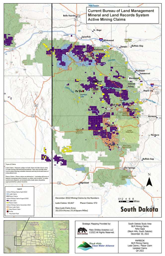
The proposed mineral withdrawal “to protect cultural and natural resources of the Pactola Reservoir–Rapid Creek Watershed, including municipal water for Rapid City and Ellsworth Air Force Base […] from the adverse impacts of minerals exploration and development” was published in the Federal Register on March 21st. It included two columns’ worth of descriptions of areas to be included. All told, the publication claims, it adds up to about 20,574 acres.

Does that seem like a lot? I’m sorry to say that it’s not. By comparison, in January of this year, the Biden Administration announced a mineral withdrawal of over 225,000 acres in the Superior National Forest, adjacent to the Boundary Waters Canoe Area Wilderness.

Map of the Central Black Hills of South Dakota with an outlined of the Rapid Creek Watershed, entitled "Future Designated Recreation Area Pennington and Lawrence Counties, South Dakota" with Rapid Creek Watershed Action logo
Map of the Rapid Creek Watershed from Rapid Creek Watershed Action (RCWA). RCWA has been working to secure a mineral withdrawal in the entirety of the Rapid Creek Watershed via Congressional action.

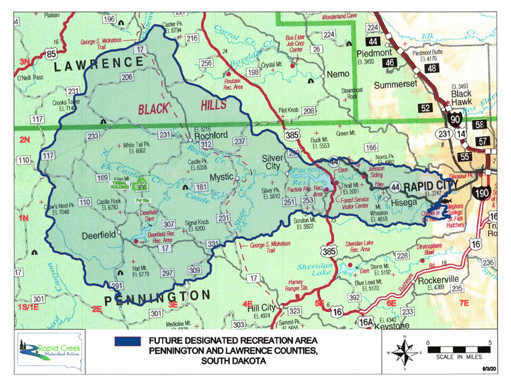
The area of the Rapid Creek Watershed upstream from Rapid City–from its dual headwaters on tributaries of the North Fork of Rapid Creek and tributaries of the South Fork of Castle Creek above Deerfield Reservoir–is approximately 198,000 acres.

This proposal withdraws from potential mineral exploration and large-scale mining about 10% of a watershed that serves as the primary water supply for an airbase, thousands of rural residents, and the state’s second-largest city.

That’s not a lot of protection.

In fact, it appears that the only areas to be withdrawn from potential exploration and large-scale mining operations are in the immediate Pactola Reservoir area, including portions of Silver City, which happens to be right on the doorstep of F3’s proposed Jenny Gulch gold exploration project.

Silver City is a tiny, isolated, historic mining community. The county road to get there is narrow, winding, and treacherous. A lot of folks in Silver City don’t own the mineral rights underneath their homes, and you’ll see signs to “Protect Rapid Creek” prominently displayed in most every yard.

It’s entirely possible (based on a preliminary map I’ve seen) that while this proposed mineral withdrawal may protect some individual property owners in that community, it may not prohibit a single drill pad in nearby Jenny Gulch.

While F3’s Jenny Gulch proposal is on most folks’ radar here in the central Black Hills, it is far from the only potential exploration or mining site on or near Rapid Creek and its tributaries. Mineral Mountain Resources has numerous active claims in the watershed, and has conducted formal exploration near Rochford. Claim activity in the Black Hills has skyrocketed in the past couple of years–in part due to a rise in gold prices, and in part due to the discovery of hard rock lithium deposits.

Map of active mining claims in the Black Hills, dated December 30, 2022. Credit: Black Hills Clean Water Alliance. Prepared by Mahto Ohitika Analytics, LLC
Image from Black Hills Clean Water Alliance

Protecting watersheds and water supplies means understanding how water flows, both above-ground and below

Thanks to research from U.S. Geological Survey, South Dakota School of Mines (which educates far more environmental engineers than mining engineers these days), state agencies, and others, we’ve got a lot of resources to call on when it comes to understanding the Rapid Creek Watershed. The Black Hills is an incredibly complex area of uplifted geological formations, and we don’t know everything about subsurface fractures, fissures, and flows. But we know a lot.

We don’t need in-depth research to understand some concepts, like the fact that water generally flows downhill and downstream. It’s also easy to grasp that, if we rely on water supplied from a reservoir, we need to protect that reservoir from contamination threats. But, if we only protect the areas around a reservoir without protecting the waterways upstream flowing into that reservoir, we’re not protecting the water supply.

Protecting Pactola alone won’t protect our water supply

Protecting the Rapid Creek Watershed means protections have to extend upstream. If we don’t extend protections upstream, we risk contamination of Deerfield Reservoir, Pactola Reservoir, and everything that flows out of them.

There are plenty of active mining claims downstream from the Reservoir as well. And below Pactola Dam is where it gets (to my mind) even more interesting.

Those outcrops of water-bearing rock formations (aquifers) high in the central Black Hills that feed water into Rapid Creek year-round are also exposed at lower elevations just outside Rapid City limits. And when Rapid Creek flows across those exposed, porous rock formations, a LOT of water (to the tune of a few million gallons a day) gets dumped back into those aquifers.

Those aquifers–the Madison and Minnelusa–are the main formations that Rapid City and Ellsworth Air Force Base (as well as thousands of rural resident and smaller water systems) wells draw from.

There’s no pipeline from Pactola Reservoir to Rapid City or Ellsworth Air Force Base.

Rapid Creek itself is the “pipeline”–and one that supports agricultural activities, timber production, a world class trout fishery, and all manner of other recreational and cultural pursuits all along the way.

Pactola Reservoir “reserves” and controls the flow of Rapid Creek and tributaries and releases it back into Rapid Creek below the dam, replenishing the aquifers we rely on. The City of Rapid City also occasionally pulls surface water directly from Rapid Creek to meet increased demand. When they do that, they’re pulling water out on the west side of the City–below a major aquifer recharge area in Dark Canyon, and far below Pactola Dam.

Contamination upstream from Pactola threatens the Reservoir, as well as the water that flows out of it. Contamination downstream from Pactola threatens not only the surface waters, but the aquifers those municipal wells draw from.

It’s simply false to suggest that municipal water supplies for Rapid City and Ellsworth Air Force Base can be protected by prohibiting exploration and mining only in the area immediately surrounding Pactola Reservoir.

Protecting Pactola is a great start, but it’s nowhere near enough to fulfill the stated goals of the withdrawal. It’s nowhere near enough to protect our water, our agriculture, tourism, national defense, and recreation economy–our way of life.

How to weigh in on the proposed mineral withdrawal

You can comment on the proposed mineral withdrawal via the U.S. Forest Service comment platform HERE. Comments are due by June 19th, 2023 at 11:59pm Mountain Time.

Also plan to attend the joint Forest Service – Bureau of Land Management public meeting on Wednesday, April 26, 2023, 4-8 p.m., Mountain Time (MT), at the Best Western Ramkota Hotel, Conference Hall, 2111 N. LaCrosse Street, Rapid City, South Dakota 57701.

Information regarding the proposed withdrawal will be available at the Black Hills National Forest, Forest Supervisor’s Office, 1019 N. 5th Street, Custer, South Dakota 57730 and at the BLM Montana/Dakotas State Office, 5001 Southgate Drive, Billings, Montana 59101.

Another Path to Protection…

There is more than one path to a mineral withdrawal. The currently-proposed withdrawal is an administrative action which, if approved, will last a maximum of twenty years. It’s important to support it, AND to push for its expansion.

The team at Rapid Creek Watershed Action is working toward a Congressional withdrawal that, if enacted, would protect the entirety of the watershed upstream from Rapid City, and would be permanent unless repealed. You can learn more, and sign the petition for Congressional withdrawal, at rapidcreekwatershed.org.

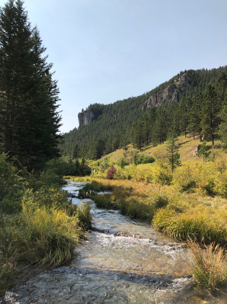
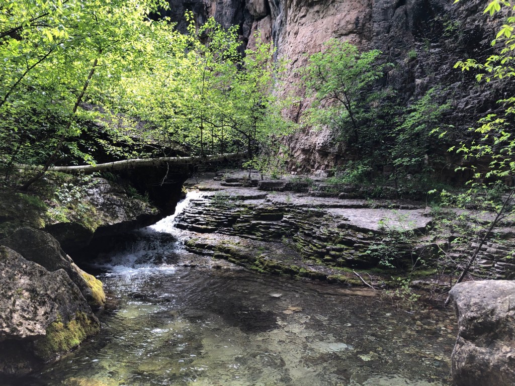
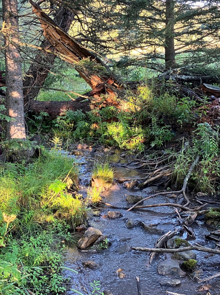
Photos of the Rapid Creek Watershed in this post include Dark Canyon, Rhoads Fork area, Victoria Creek/Canyon, and Nichols Creek. They were taken by the author.

This is a Post About Drought. And Farmer Suicide.

I traveled to Pierre on Saturday from my home in Northeastern South Dakota–a tiny little nook of the state that is green, lush, and lucky with moisture. We had edged into abnormally dry status in the last drought monitor update dated 7/25, but the nearest weather station update records nearly an inch of rain that day–and I’m fairly certain that in our little corner we absorbed twice that or more late that afternoon and into the evening.

20170725_SD_trd

The afternoon of the storm, I was trudging around a Nature Conservancy prairie preserve in Deuel County, and as I was leaving lightning was flashing in the distance and dark clouds edging in from the north and west. As my companion drove us back into Clear Lake, there was a solid gray wall bisecting upper Main Street from lower–a wall of absolute deluge. Despite being parked directly next to the driver’s side door of my vehicle, I had to wait about five minutes before the downward-facing firehose let up.

It’s a different story elsewhere in the state.

I travel to Pierre once or twice a month, so I knew already the stricken landscape that is central South Dakota. When I was there ten days ago, the bindweed (whose roots can extend thirty feet deep in the soil) was the last green thing remaining in the un-irrigated hillside lawns in town. Now it too has browned out.

This time, I was in the area for a tour of B&G Produce farm near Canning and meeting of the Greater Oahe Action League (GOAL) Chapter of Dakota Rural Action. Because of Matt and Lindy’s stewardship of water resources through drip irrigation, the beds of produce there were green and lush–but in between the rows, the soil was powder-dry.

Matt Geraets, who led the tour, told us one of his challenges this summer is pocket gophers–not their tunnels or depredations of the crops themselves so much as that they are chewing holes in the irrigation lines because there is no water to be found anywhere else. Powerful dust devils are also an issue–one whipped off a fifty-foot length of row cover, sucked it up in the air, and deposited it…well, they don’t even know where it ended up.

In attendance on the tour were a number of town folks and a farm couple who raise mostly small grains north of Pierre. I won’t mention their names, but I’ll say that I fell into conversation with them as we walked to the far fields of tomatoes, peppers, and squash. He said that he’d just plowed under his sunflower crop, and I naively asked if there might be any allelopathic effects of the plowed-down crop on a subsequent one.

[For the uninitiated, allelopathy refers to the positive or negative effects of one crop on another–sunflowers are known to have a negative effect on some other crops.]

He chuckled and said, “well, I doubt it, since I only had a 10% stand.” Meaning, only about 10% of his crop even had enough moisture to survive. Yeah. It’s bad out there. And, considering the conditions, there isn’t really the ability to plant a late crop–even a cover crop to protect the barren soil. When weeds with roots a dozen feet down can’t survive, there probably isn’t anything else that can, either. Except the farmers themselves.

Which brings me to the next point. And that is this: it’s too late to save the crops. It’s too late for the grass to come back or to have enough to feed all the cows through the winter. But it is NOT too late to save the farmers and ranchers, and we’d better start talking about that. Right. Damn. Now.

That point came to me later in the morning, after I’d traveled a much larger swathe of the Crow Creek Reservation than ever before. I was heading down to Chamberlain to see a friend who’s a mentor to me, and whom I’d not seen for a couple of months. It was early in the morning, and I saw a detour I thought I was supposed to take–though looking back I kind of wonder if it was a necessary turn. Whatever. I had time.

Crow Creek storm
Too little too late–storm clouds north of Crow Creek.

The sign said, “Detour BIA 3,” but as far as I know, I was on SD 50. There was also a “ROAD CLOSED TO THROUGH TRAFFIC” sign (I think–but maybe I just remember that wrong because I saw a lot of other signs like that before I got to where I was going). I had a half tank of gas, so, why not? I took the dirt road out through the pastures.

It ended up taking an extra hour to get to my friend’s place. I saw a lot of miles with a lot of cattle on a lot of dried-out grass. And then I finally found a crossroads with actual multi-directional signs and stopped to pull my gazetteer out of the backseat.

[Pro tip: rural travelers do not depend on navigation apps.]

I was east of my target destination, and apparently I was smack dab in the middle of the town of Shelby. Let me relieve you of the notion that there is an actual town there–there is a ranch there, but a town there isn’t. Still, I now knew exactly where I was and how to get where I was going.

After I related the previous night’s conversation, my friend told me she’d attended a recent meeting in that area on the topic of the drought. There were dozens of local farmers and ranchers there, and although folks sat with other folks they knew, there wasn’t the usual jovial atmosphere of previous gatherings she’d seen. The discussion focused on belt-tightening–the corn cut for hay (not wet enough for silage), the recommendation to return newly purchased and rented equipment. How many cows to sell off.

And then one of the professional presenters who’d started her presentation on drought effects abruptly stopped, removed her glasses, pulled up a slide, and started to cry.

The slide was the suicide hotline.

This is where we are at, folks. It is better that we start talking about it now. Now, before we lose anyone–though in saying that, I realize that I don’t actually know that. Maybe we’ve lost people already. Maybe we’ve lost people and there’s nothing in the obit column that makes it clear this is why. We’d better start talking about it. Right. Now.

I’m a child of the 70’s, and I grew up in the 1980’s. I grew up in the Champlain Valley of Vermont, which is a region that was, at that time, rich in dairy farms. And then came the farm crisis and the whole herd buyout. My school was a mix of kids whose parents worked for the ultra-spendy liberal arts college, kids whose parents worked white and blue collar jobs or no jobs at all, and farm kids–mostly dairy. Some kids whose parents sold out their herds and moved to town. I was young enough and sheltered enough then that if the worst happened, I would never have heard the reasons behind it–though farmers in the Northeast had a much lower rate of suicide than those in the West and Midwest.

Now that I’m older, and I’ve worked for a couple of organizations that formed during the farm crisis of the 80’s, I’ve learned the history of what happened, and I see many of the same factors playing out today. Commodity prices have crashed. We have an administration threatening to gut USDA Rural Development funding. And, here in South Dakota (as well as North Dakota and Montana), drought is hitting hard.

According to a University of Iowa study, over a thousand farmers took their lives during the 80’s crisis. And the rate of suicide among farmers and farm workers has remained higher than in other professions.

As in the 1980s, financial issues continue to cause some suicides, especially during economic crises or periods of extreme weather, Peek-Asa says. But farmers face an array of other stresses that put them at high risk for suicide: physical isolation from a social network, leading to loneliness; physical pain from the arduous work of farming; and lack of available health care resources in rural areas, especially mental health care.   Snee, Tom. “Long after 80’s farm crisis, farm workers still take own lives at high rate.” Iowa Now. 6/12/2017.

Right now, we are seeing the double-whammies of economic crisis and extreme weather in some states–the very factors that can cause a spike in suicides.  We’re seeing our rural communities hollowed out by federal farm policies still operating on the, “get big or get out” model that we known damn well is killing us–in some cases literally. It is bad out there, and it is getting worse.

But, one thing we do have that we didn’t at the start of the eighties is a host of organizations and support networks formed during that time of crisis. Many of them are still here, still doing good work to challenge the policies that are failing people in farm country, and still fighting for family farmers and ranchers.  And many of them also help connect farmers and ranchers to support networks and communities of neighbors that can alleviate the isolation and feelings of despair.

I’m not a counselor. I’m a rural organizer. I care about farmers and ranchers and our rural communities, and I’m worried for our people. My friend in Chamberlain has been trying to get local bankers and business owners to talk about the drought for months now and has gotten virtually no acknowledgement that it exists. I’m worried that we won’t really admit how bad things are until it’s too late. I’m worried we’ll lose people.

So, let’s start talking about it. Right. Damn. Now.


Here is the South Dakota Helpline Center link.

Their suicide hotline number is 1-800-273-8255. 

Here’s a link to the Farm Aid Crisis Support page. Farm Aid was formed in 1985 to “raise awareness about the loss of family farms and to raise funds to keep farm families on the land.” They also fund the work of organizations like Dakota Rural Action, where I’m employed.

Don’t be a stranger. Visit your neighbors. Take care of yourself.

And don’t wait to ask for help.